Total Pageviews

Showing posts with label Pacific Palisades. Show all posts

Saturday, December 6, 2014

Re-imagining the Bay Theater: Caruso Development in Pacific Palisades

This past week, Los Angeles based developer Rick Caruso unveiled a plan to update and re-vitalize the business district in the Pacific Palisades, an upscale coastal community on the western-most edge of the city of Los Angeles.

With a vision to bring a re-imagined version of the long defunct Bay Theater as part of the plan, local residents seem excited to see this move forward. Of course, there are detractors who are concerned about traffic (what else is new), parking, or that it looks too much like Caruso's "The Grove" complex. 

Considering the cost of putting together a project like this, I'm surprised how low density it actually is. Everything is limited to one or two stories, and the plan even includes a small park to replace a current parking lot.

Having grown up in the Palisades - back in the 1970's, when the community was much more "middle income" - it looks pretty stellar. 

Here's a link to a story in Curbed Los Angeles, with more photos and a ten minute promotional video. 

© 2014 www.experiencingla.com
-


Saturday, September 27, 2014

Experiencing L.A. - Costal Fog & Paseo Miramar Trail at Sunrise, Pacific Palisades (Part 2)

Looking for a workout? A chance to experience L.A. in perhaps a totally different way? Then perhaps the Paseo Miramar trail over in Pacific Palisades is for you!

Hard to believe, but the Paseo Miramar trail is all within Los Angeles city limits. Located in the Pacific Palisades district of L.A. this hike offers views of the mountains, hillside homes, the city, and the ocean. And in the spring and early summer, while the rest of the city is blanketed under June Gloom, coastal fog. 

Time in right and you'll catch the sunrise. 

There's no "bad" time of the year to go,  but experiencing the fog up against the Santa Monica mountains can be pretty spectacular. 

The same view, more of a wide angle shot. Los Angeles experiences a weather phenominon referred to as "June Gloom" in the spring and early summer. As a result, at the beach it can be sunnier - and even warmer - in January than June. In the distance, barely visible, is the outline of the San Garbriel Mountains. 

Same view, wider view. 

Fog, hillsides, palm tree, sunrise. 

On a clear day, this would be looking towards the Santa Monica Bay and Pacific Ocean. Instead, simply an amazing sea of fog. 

The Paseo Miramar trailhead is located at the top of Paseo Miramar, off of Sunset Blvd, 1/2 mile north of Sunset Blvd and the PCH. Thanks to being listed in numerous websites, including the Los Angeles Times "10 Essential Hikes" - this is a very popular hike. Parking is on the street. As stated last week, please keep the noise down and respect the quiet of the neighborhood (no one wants to be woken up by a group of friends meeeting at the trailhead early Saturday morning). 

© 2014 www.experiencingla.com


Saturday, September 13, 2014

Experiencing L.A. - Costal Fog & Paseo Miramar Trail at Sunrise, Pacific Palisades

What does Los Angeles look like just before sunrise? What does it look like when shrouded in coastal fog? 

A couple weeks ago I posted a single image of the bluffs along the PCH in the Pacific Palisades district of Los Angeles. When we lived in Los Angeles, I made dozens of early morning hikes in that same area, most notably on the upper Temescal Ridge trail and the Paseo Miramar trail. Here's a link to a previous post on what I consider the best hike in L.A. This week, I'll focus a bit on the Paseo Miramar trail.

There photos are from 2010, our last Spring living in L.A. This is looking east from the Paseo Miramar trail (technically a fire road) towards the office towers of Westwood, Century City, and Downtown Los Angeles..The San Gabriel Mountains are visible in the distance to the left.

The hike is very steep - a great workout. The coastal communities of Pacific Palisades and Santa Monica were completely shrouded in low coastal fog. Because this is so common in the Spring and early summer, this is often referred to as "June Gloom" or "May Gray."

Looking out over the Pacific Ocean - and the vast sea of coastal fog. This is only at about 1200 foot elevation. 

The fog hugging the coast. Most days, it burns off by noon, and then rolls back in the evening.

Another view of the fireroad - and the fog. 

Coming back down, we spotted another hiker along the the trail.

Another view of the same guy. 

This is a reminder of the unique topography and climate of Los Angeles. How, in many ways, it's unlike any other city in the world. 

A final view looking east with the hillside homes of Pacific Palisades and the coastal fog in the distance. 


The Paseo Miramar trailhead is located at the top of Paseo Miramar, off of Sunset Blvd, 1/2 mile north of Sunset Blvd and the PCH. Thanks to being listed in numerous websites, including the Los Angeles Times "10 Essential Hikes" - this is a very popular hike. Parking is on the street. Please keep the noise down and respect the quiet of the neighborhood (no one wants to be woken up by a group of friends meeeting at the trailhead early Saturday morning). 

© 2014 www.experiencingla.com


Saturday, August 30, 2014

View from the Jetty: Pacific Palisades

image credit: oneillsfineart.com Katie O'Neill


I recently came across this outstanding image: "View from the Jetty" by Los Angeles based artist Katie O'Neill. I love how she captured the bluffs and coast at sunset. This is looking north in the Pacific Palisades district of Los Angeles, located in between Santa Monica and Malibu. Seemed most appropriate for this last weekend of summer.

Here's a link to her website, with additional images and more information.

Happy Labor Day.


-

Saturday, March 16, 2013

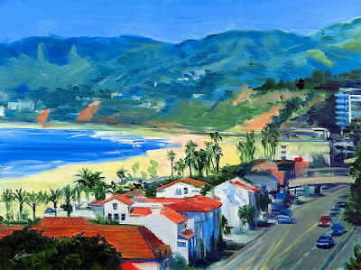
"View Of Pacific Palisades and PCH from Santa Monica"

Los Angeles area artist Warren Keating's View Of Pacific Palisades and PCH from Santa Monica does a fantastic job capturing the beauty and appeal of coastal Los Angeles. Click on the image if you'd like a slightly larger view. More information can be found at www.KeatingArt.com.

© 2013 www.experiencingla.com


-

Saturday, May 19, 2012

Experiencing L.A. - Clearwater Mural, Pacific Palisades

While murals are not unique to Los Angeles, this large color mural covering the loading dock of the CVS pharmacy in Pacific Palisades certainly caught my eye. 

Wow, beautiful. 

Even the dumpster looks good!

Another perspective. 

Looking towards the street.

The Clearwater Mural is the work of local artist Terri Bromberg. Originally painted in 1999, it was restored and expanded in 2004 and then later in 2010.

Back in 1978, I painted a similar - although much, much smaller - mural on my High School locker about a mile away - at Palisades High School. This was when Star Wars was still in theaters and was all the rage. I checked with the Vice Principal ahead of time (who said that while he couldn't give me permission, as long as I didn't paint anything offensive, it would be OK). While much more modest in scope, it was a similar labor of love. 

Unfortunately, unlike the Clearwater Mural, it didn't have the protection of private security or hidden cameras - and was destroyed within a week. I tried to restore it, but after more vandelism, I just gave up. Yeah, sad. 

     www.muralconservancy.org

What can I say? It's really depressing as there are dozens a massive murals around Los Angeles have been destroyed by graffiti. And, of course, the poorer neighborhoods have a disproportionate share of this sort of vandelism. 

Fortunately, there are still many amazing murals to be found. But even they have to deal with the elements. 

           federicodecalifornia.files.wordpress.com

Here's a quick before/after of what thirty years of bright sunshine and rust have done of the nearby "Isle of California" . . . 


. . . perhaps the most famous mural in the entire city. 

Even the photos on this, and every other website around the world, are simply sitting on some server and won't last forever. That doesn't mean that art and artwork shouldn't be encouraged, celebrated and protected. But even works locked away in museums are, ultimately, temporal. 


Many thanks to Terri Bromberg, the sponsors of the Clearwater mural, and the managment of CVS for supporting this project. Here's hoping that it'll be around for my great grandkids' generation to enjoy - 100 years from now. 


View Clearwater Mural, Pacific Palisades in a larger map

Here's a map to the Clearwater Mural, located just off of Sunset Blvd. in Pacific Palisades. 

© 2012 www.experiencingla.com


.

Saturday, May 5, 2012

Experiencing L.A. - High Peak, Pacific Palisades


When I was in Elementary School, my mom, dad, sister, and I - along with a friend - hiked from Sunset Blvd and Temescal Canyon all the way to Skull Rock (picture above). As as kid, the round trip hike took us about five hours (as an adult, the same hike takes 90 minutes).

I remember my dad saying "next time, we'll hike up to the top of that next peak" (above). Unfortunately, there was never a "next time" - and we never made that hike. 

It's called Goat Peak, at least it was a long time ago. I've never heard anyone call it that. I called it "1729" (which is it's elevation). Everyone else refers to it as High Peak. Let's go with that. 

I bought a trail map a while back. No trail to the top. Hmmm. 

But thanks to Google Earth, I was able to discover that, yes, there is an unnamed trail, and even found the trailhead (at the top of Chautauqua Blvd, in Pacific Palisades).
Four years ago, while we were living in Los Angeles, I finally hiked to the top of High Peak. The photo above was taken about 6am near the base of the trail, with High Peak in the distance.

It's a challenging hike: steep inclines in places, loose rock, and literally some rock climbing towards the top. However, the views at the top are simply spectacular. The photo above does not do it justice. It was close to a 360 degree view.
Continuing on there is a slightly visible trail along the ridge, which is the east ridge of Temescal Canyon. April and May are great times of the year to go with some beautiful wildflowers in bloom.

Continuing on for about a mile, this unmarked trail actually hooks up with the "Rogers Road" trail, which I took back down into Will Rogers State Park. Again, until you get to the Rogers Road trail, it's an unmarked trail, and is difficult to follow in places. I do not recommend this as a "first hike" and, unless you're familiar with Santa Monica Mountains, would not recommend trying it alone.

Looking again at my topographic map, I found that, indeed, there is a trail that I had never noticed before. If you click on the map for a larger view, you can clearly see the trail.

Challenging but do able. From the Chautauqua trailhead to the top of High Peak took about an hour. It was worth it. And all within the city limits of Los Angeles.

Here's a map to the trailhead in Pacific Palisades. 

© 2012 www.experiencingla.com - originally posted 5/28/2008


.

Saturday, January 7, 2012

Experiencing L.A. at Sunset & the PCH


Two years ago I was driving along the Pacific Coast Highway (PCH) just south of Gladstones Restaurant at Sunset Blvd in Pacific Palisades around 10am on a Friday morning.


What caught my attention was how how incredibly crowded the surf spot was. I'd never seen it so packed.


I pulled over and took a few pictures. Here's a wide angle shot - the rock outcropping to the right is where Gladstones Restaurant (corner of Sunset Blvd & PCH) is located. For people out of the area, this is all within the city limits of Los Angeles.


A winter storm elsewhere in the Pacific made for some ideal surf conditions here in Southern California.


Surfing is perhaps the only sport I can think of where those involved don't necessarily want others to join them (especially at "their" spot).


Everyone was crowded in this one spot because this is where the waves were really breaking. A couple hundred yards away, the water was literally empty. And, of course, with temperatures (water temperatures) in the 50's, everyone was wearing a full wetsuit.


I love this shot. One photo. Twelve guys up on three (or is it four?) different waves. Wow.

And how many guys are waiting for the next set? Over fifty. It was a Friday morning. Don't people have jobs? Oh yeah, forgot: this is L.A.


Here's a map to this "not so secret" surf spot, located a quarter mile south of the intersection of Sunset Blvd. and the PCH (Pacific Coast Highway) in Pacific Palisades.

photo credit: Don Bartletti, Los Angeles Times

Meanwhile, a storm somewhere in the Pacific this week (January 2, 2012) made for some great surf. This is from Los Angeles Times photographer Don Bartletti, with a link here to a series of outstanding photographs from the most recent swells.

© 2012 www.experiencingla.com - originally posted 1/17/2010


Saturday, December 10, 2011

It's a Bird, It's A Plane: Motorized Parachute over L.A.


Motorized Parachutes - more commonly known as Powered Parachutes - are not unique to Los Angeles. In fact, because they're much more commonly found in rural settings than urban ones, what is unique is seeing one buzzing around the edge of the city.

I say "buzzing" because at this point the pilot was no more than fifteen feet off the ground. In our five years in Los Angeles, this was the one and only time I saw something like this. Really cool.

I would LOVE to try something like this!

On the other hand, I'm not sure if this was even legal. Maybe that's why this was the one and only time I saw this. If you happen to know the laws for flying a Powered Parachute in urban areas - or have seen these in or around Los Angeles - please leave a comment!

The pilot initally came in from the south along the beach from Santa Monica, did a tight turn near where we were standing (at the Los Angeles city limit: PCH & Coastline Drive), and then headed back to Santa Monica. Looks really fun. My brother-in-law, who loves flying, would especially dig something like this.

Actually, so would I. Making it another "experiencing L.A." moment.

© 2011 www.experiencingla.com